At the Widow Pratt’s (The Royal Standard Tavern on Market Street), at
four o’clock on the afternoon of May 16, 1752, the actual mechanics of
running Philadelphia’s first fire insurance company, The Philadelphia
Contributionship for the Insurance of Houses from Loss by Fire, were resolved.
The Directors clearly felt that the surveying of prospective properties, to
be certain they were acceptable risks and to determine value, was of the highest
priority. They appointed two of their own members, Joseph Fox and Samuel Rhoads,
as Surveyors for the year, stipulating that at least one of them survey each
house and resolved to allow each Surveyor two shillings and sixpence for “Surveying
and reporting the state of the Buildings to be insured in one property.” These
surveys or reports would then be discussed by the entire Board at the next
meeting, at which time a decision would be made as to the extent and rate of
insurance.
The actual cost of the survey was presumably deducted from the 10 shillings
earnest money paid by every person insuring in the society. This also covered
the costs of the policy and the “badge” or fire mark. Insurance
at this time was limited to properties in Pennsylvania located within a ten
mile radius from the center of Philadelphia. If the property to be surveyed
was located two miles or further from the Contributionship’s office,
the owner was required to pay the costs of the Surveyor’s journey.
The custom of surveying properties derives from English insurance practice.
From their earliest days companies such as the Hand-in-Hand or Amicable Contributors
for Insuring for Loss by Fire (1696), the Sun Fire Office (1710), the Union
Fire Office (1714), and the Westminster Fire Office (1717), employed surveyors
to inspect properties prior to their acceptance for insurance. The founders
of the Contributionship, who modeled its structure after that of the English
Hand-in-Hand, certainly perceived the need for expert surveying. Like their
English counter parts, they chose carpenters for this task—two of the
most noted master builders in the city.
Joseph Fox (1709–1779) and Samuel Rhoads (1711–1784) both served
as presidents of the Carpenters’ Company of Philadelphia, a prestigious
and influential builders’ organization which resembled the guilds of
London. They served as joint contractors for the building of the east wing
of Pennsylvania Hospital in addition to their individual projects and did extensive
surveying and measuring. Both were politically oriented, serving on the city
and provincial levels and were active in the Revolutionary movement. Rhoads
was a delegate to the First Continental Congress. They also devoted consider
able time to philanthropic activities. Both were personally as well as professionally
interested in the success of the newly formed Company.
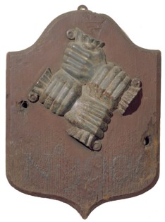 Fire mark of The Philadelphia Contributionship, No. 1906, ca. 1775, made by Jospeh Rakestraw.
As Surveyors, their responsibilities were generally limited to reports of
prospective properties and presumably the overseeing of the repair of fire
losses. In 1755, they also promised to see that all insured houses had fire
marks attached. Subsequently Nathaniel Goforth and Joseph Rakestraw were employed
for that purpose. As Directors of the Contributionship, Fox and Rhoads, together
with the others, fixed the rates of insurance, set guidelines, and inspected
fire losses.
Early surveys done by Fox and Rhoads were precise; they listed the owner and,
if the building was not owner-occupied, the tenant, the location, type of structure,
dimensions, number of stories, thickness of party walls, and construction,
noted if the property had railings on the roof or trap doors (fire safety measures),
and recorded distinctive features such as the type of stairs. All of these
factors were considered in determining rates. Brick buildings with nine inch
party walls and a door out onto a roof surrounded with iron rails received
the most favorable rates, whereas wooden houses with “plaistered” wooden
partition walls were subject to the highest premiums and ultimately banned.
The 1760s heralded the first changes in the Company’s surveying practices.
Rhoads and Fox declined reappointment as the Company’s Surveyors in 1762
and subsequently resigned from the Board, Fox in 1762 (he returned to serve
again from 1767–1779) and Rhoads in 1763. In their place, Gunning Bedford
and William Dillworth were appointed Surveyors and were simultaneously elected
to the Board. Like Fox and Rhoads, Dillworth and Bedford were members of the
Carpenters’ Company, Bedford serving as President from 1791 to 1794.
This was a strong tie that was to be broken only twice in the next 127 years.
Undoubtedly the Carpenters’ Company comprised the most skilled builders
in the city, and their members had strong political connections. Even more,
however, this organization had secret schedules for pricing carpentry. Gunning
Bedford was most influential in this latter endeavour, serving on the company’s “Book
of Price” committee from 1767 to 1790. This book, which quoted going
prices for specific types of carpentry work, circulated only among members
of the Carpenters’ Company. The Contributionship through its Surveyors
profited by this, enabling them to arrive at a solid basis of valuation and
a fair assessment of damage done by fire to settle the claims equitably. Company
policy at this time was to pay the value of the policy if the loss was total;
if the building was merely damaged they would estimate the loss and offer the
owner that amount or employ someone to repair the property.
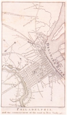 Map from
 The Traveller's Directory
, printed by Matthew Carey, 1804, showing
a section of the road leading north to New York. "1 M" and "2 M" refer to
the location of the Contributionship's milestones.
William Dillworth died in 1765 at the age of 40 and Samuel Wetherill, Jr.,
was chosen in his place. Wetherill’s election marked a major change.
Although undoubtedly a skilled carpenter, he was not a member of the Carpenters’ Company,
but instead was one of the organizers of the Friendship Carpenters Company
in 1769, a rival company of young Philadelphia carpenters. They issued their
own price guide, one apparently at variance with that issued by the Carpenters’ Company.
Attempts to remedy this problem proved futile until 1785 when the Friendship
Company was absorbed by the Carpenters’ Company, and a new price guide
was issued. Certainly it was to the advantage of the Contributionship to have
Surveyors from opposing camps on the Board at this time to ensure an equitable
system of valuation. As members of the Friendship Company realized in 1769,
fair systems of measuring had to be employed so that the most harmonious arrangements
could be made between the carpenters and owners. When the woodwork and trim
on houses became more ornate, it was only reasonable to assume that they could
not be done for the same price as plain finishings. Surveys became slightly
more detailed at this point as buildings became more elaborate, and presumably
the price books had an impact on the types of detail needed in the surveys.
As with Bedford and Dillworth, the surveys appear to have been assigned evenly
to Bedford and Wetherill.
In 1768 the Directors of the Contributionship apparently felt the need for
additional safeguards. They required that the Surveyors record their surveys “in
a Book provided for That purpose.” For this additional labor, they would
receive sixpence per entry. Bedford and Wetherill each received their own book and faithfully recorded each survey.
The clerk also ordered "not to issue any Order for a Survey on any House
out of the City, until iron Rails are put up on the top thereof, and a trap door made,
Nor to issue any Order to the Surveyor until the Earnest Money is received."
(Minutes, April 12, 1768). In this period, when the area west of Seventh Street was
still largely wilderness, distant journeys were not taken lightly. Initially the
Company could use the 1752 Scull and Heap Map of Philadelphia and Parts Adjacent
to roughly determine the location of outlying properties. It was not until the publication
of hte 1808 John Hills' Plan of the City of Philadelphia and Environs, which
clearly marked landmarks and property divisions within a ten mile radius of Philadelphia,
however, that the Surveyors could even guess at the desirability of a property without
prior knowledge or determine whether it fell within their prescribed limits for insurance.
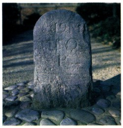 Milestone, ca. 1768, erected by order of the Directors of the Contributionship in
Marcus Hook, Pennsylvania, on the road south to New Castle.
Milestone, ca. 1768, erected by order of the Directors of the Contributionship in
Marcus Hook, Pennsylvania, on the road south to New Castle.
One aid to determining distance was the erection of milestones. In 1761, the Directors
of the Contributionship decided to apply their fines (for tardiness or absence from meetings)
towards the purchase of milestones to be place on the road north to Trenton. In 1764, Peter
Reeve, Joseph Saunders and Thomas Wharton procured the services of Philip Syng, Jacob Servis,
Thomas Gordon, and the Surveyor General John Lukens in measuring the distance and placing the
stones. They placed 29 on the road to Trenton and two on the road to New York. Each stone
bore the coat of arms of the Penn family on one side and the distance in miles to
Philadelphia on the other side. This venture proved so pupoular that in 1765 the
Directors resolved to apply subsequent fines toward the purchase of stones for the
road south to New Castle. While this was basically done in the interest of public
service, these stones should have helped the Surveyors locate properties more accurately.
Major political and financial problems plagued Philadelphia in the 1770s, and
after 1776, the impact of the Declaration of Independence was felt at the Contributionship.
In 1777 the amount of earnest money was increased to 17 shillings because of the higher
cost of the lead used in the manufacture of fire marks. In 1779, the policyholders left
the decision to change the amount of earnest money required to the discretion of the Directors. At this time it was rasied to £4, clearly the result of the low value of the continental currency.
Joseph Rakestraw, the nephew of Joseph Fox, was elected a Surveyor in 1778 when Samuel
Wetherill, Jr., moved out of the province. Wetherill’s removal was brief; in 1779 he was
disowned by the Society of Friends for his role in the Revolutionary War, and he returned
to Philadelphia to found the Society of Free Quakers in 1781. In the interim, Wetherill
had become a merchant dealing in cloths, and in later years, chemicals, apparently finding
this a more lucrative career than carpentry.
Rakestraw’s association with the Company started in 1758 when he began to make and erect
the Company’s fire marks. He continue this practice after his election as Surveyor and it
became a part of the duties of the post, although he received an additional stipend for
each mark erected. His tasks during this period were light; no new policies were written
between August 21, 1778 and April 20, 1781, probably as a result of both the war and the
currency problems. Business revived in the 1780s and Rakestraw supplemented his income by
doing some of the fire repairs himself.
For all of these men, surveying was not the only source of income. Rakestraw did the
State House repairs in 1788 and helped oil the construction of both the Library Company
and the President’s House. Similarly, Gunning Bedford was involved in numerous
construction projects including the Second Presbyterian Church (with Robert Smith) and
the Triumphal Arch erected in January 1784 to celebrate the ratification of the Treaty of
Peace. Ironically, fireworks placed too closely to the frame of the arch caused a
spectacular conflagration.
Upon the death of Joseph Rakestraw in 1794, David Evans (1733-1817) was appointed
Surveyor, and to affix the fire marks. After the death of Gunning Bedford in 1802,
Evans carried on the responsibilities of the Surveyor alone. Evans supervised the
repair of fire losses and was responsible for the procuring of materials, but it
appears he employed others to do the actual work. Among them was his son, David Evans,
Jr., who worked together with him on other projects, including the completion of
Pennsylvania Hospital in 1794.
In the first decade of the nineteenth century, Evans recommended another carpenter
to the Board for fire repair work, John Evans, whom he described to John Dickinson as
“a distant Relation of mine lives next door to me. I have employed him to Repair
several Burned Buildings for the Insurance Company and he has done them to the satisfaction
of the Owners as well as the Directors of the Company.” (Logan Papers, v. 33, p. 64,
Historical Society of Pennsylvania). Presumably this is the same John C. Evans who was
elected to the Board of Directors in 1806 and succeeded David Evans as Surveyor in 1810.
John C. Evans’ tenure as Surveyor (1810-1850) was marked by numerous breaks
with tradition. Not only was Evans not a member of the Carpenters’ Company, but
also after 1819 he no longer served on the Board of Directors of the Contributionship.
He became the first “free lance” Surveyor of the Company. Evans’
account book in 1818 states, “As Surveyor John C. Evans is entitled to Six Dollars,
each Survey including Badge and fixing where the party makes Ensurance. On Surveys not
taken he is entitled to three Dollars each.” Evans kept careful records of all
houses surveyed, badges delivered, and fees owed him. Entries in red indicated that a
property previously surveyed was accepted for insurance and that an additional $3 was
owed for the delivering of the policy and affixing of the badge. In 1810 the Company
switched to perpetual insurance and, as one of their new safeguards, required that all
policyholders sign the survey. This policy continued throughout the nineteenth century.
Evans’ memoranda books indicate that it was he who delivered the policies,
presumably having the owner sign the survey at this time. He also was careful to note
where the policy was delivered.
Evans periodically resurveyed buildings, as had his predecessors, if the insurance
had been in effect over a number of years or if alterations had been made. He also
continued doing the fire repair work for the Company. Despite his meticulous record-keeping
no books of recorded surveys exist after 1837 and it seems probable that the practice
of copying surveys was discontinued at that time.
In 1836 it was decided that the Surveyor should report to the Company at least once
daily, and that has compensation should be $3 for each survey when the property was
accepted (the use of badges had declined, consequently the $3 fee for affixing them
was dropped), as well as the charges for all resurveys and surveys on non-insured
properties, If the total amount of compensation was below $500 annually the Company
would pay the difference. This is the first evidence of any guaranteed compensation
for surveying.
Surveys became more elaborate in the nineteenth century possibly because Evans and
his successors found it necessary to include more detailed information for estimating
values and damages in the event of fire, and partially at the direction of the Board.
In 1839 the Directors required that the Surveyor annex to each survey an estimate of
the probable value of the building to be insured and the nature of the adjoining building.
These clearly had an impact on the amount of risk incurred. As of 1842 any rooms which had
“paper hangings” were to be specifically mentioned. In 1844 the question about
the insurance of fixtures arose and it was decided that “the uniform practice of the
Office has been to include in the Survey a description of the property insured, and to refer
to the survey as a part of the policy, and to consider nothing insured which is not
mentioned.” (Minutes, July 3, 1844). It was agreed to cover the building and such
fixtures which may be used whatever the purpose of the building. Consequently it was
critical to mention anything of importance in the building and the Surveyors began to
list the various rooms in the houses, methods of construction, and to describe in detail
specific architectural and ornamental features. Occasionally the surveys were accompanied
by sketches or maps of the area. Even at this time, however, the survey was criticized for
its lack of information. In 1859 Ann Binney wrote the following comments to the Company
Treasurer.
The survey strikes me as a curious document for while it is particular
in some respects it is useless to rebuild by without reference to drawings or evidence
of various sorts not embraced in it or referred to by it. “Italian mantels”
may vary from $50 to $500 & still be free from fancy work or carving. 8 in. mouldings
may be of great variety of patterns, “ornamental iron work” is hardly definite,
“turn’ balusters of birch” may be of various patterns (size alike) &
cost variously or of “octagon newel post” & “continuous rail.”
Their cost will depend greatly on finish & dimensions. In short without meaning to be
critical it seems to me that under that survey alone no builder could rebuild or could he
repair without reference to similar work in the building remaining uninjured by the fire
– & if one must go outside of the survey to make it effectual why have it.
Possibly Ann Binney’s remarks had some effect, for by the end of the nineteenth
century the survey had reached new lengths and one might almost argue with her that one
could indeed “ rebuild by it.” The survey was extensive and often included
floor plans. Occasionally architects’ sketches, elevations, and engravings were
included as supplemental information. It was not uncommon at this point for other companies
coinsuring a property to comment in their policies that the survey was on file at the
Contributionship.
John C. Evans died suddenly of a heart attack on June 9th, 1850, at the age of 72.
Daniel Knight was chosen to replace him from a pool of nine applicants, at a salary of
$900 a year. Like most of his predecessors, Knight was a respected member of the
Carpenters’ Company (elected 1829), having served on the managing committee
for a number of years. From the beginning of his tenure at the Contributionship the
workload increased considerably, so much so that by 1852 the Directors raised his
salary to $1200 a year.
Knight’s surveys became even more comprehensive; his groundwork was aided,
however, by the introduction of fire insurance atlases – detailed maps which
covered every block of the city showing risk information useful to fire insurance
companies (location of buildings, descriptions, lot sizes, landmarks, fire protection
and prevention systems) by means of varying colors and symbols. The Contributionship
was well accustomed to using maps in their business dealings, purchasing new ones every
few years. The concept of such detailed plans offered even greater appeal, however,
and the Contributionship was among the first to subscribe to them. The first series of
such maps was proposed by Robert P Smith in 1848. These were to exhibit “in each
and every Square of the City of Philadelphia and the improved parts of the Liberties
every Lot with its number on it, (without reference to accurate measurement).”
(Minutes, November 1, 1848). It is doubtful whether this series was ever published.
In 1858 the Board agreed to subscribe to Dietrich, Hexamer & Locher’s
Maps of the City of Philadelphia showing the number and dimensions of lots in
each square and the height and characteristics of the houses and buildings. Within a
few years Hexamer and Locher began providing updates for these maps (which now
comprised 7 volumes), “so that the Insurance Co’s have all the time a
perfect set making them to correspond with all the new changes of Buildings etc. and
if necessary whole sheets will be added to the Books . . .” (Minutes, May 21, 1862).
The annual cost for updating these books was $30 which together with the original cost of
$30 a volume, the Company paid without hesitation. In 1916, the Hexamer Company was
absorbed by the Sanborn Company which had gained a monopoly in the United States in
the late nineteenth and early twentieth centuries. Again the Contributionship subscribed
to these maps. They also employed city and county land atlases, which provided much the
same detail, although they lacked the specific fire protection information. These atlases
enabled the Surveyor to determine the character of the neighborhood and nature of the risk
before ever leaving the office. As the Company had expanded its insurance limits in 1836,
it was increasingly desirable to know the layout of a neighborhood before making be trip.
In 1868 Daniel Knight retired for reasons of health. He died in 1871. He was the last
of the Contributionship’s part-time Surveyors and interestingly the first who was
not a member of the Society of Friends. He was a carpenter and builder, constructing the
double row of houses on the south side of Cherry east of Ninth Street, known as
Knight’s Court. He also appears to have been an astute businessman. He left
two properties to his daughters Elizabeth and Sallie and the remainder of his estate to
all his children advising them to wait until the market was good to sell.
The Board hired J. Louis Moore to replace Knight in 1868 stipulating that his entire
time was to be devoted to the Company. In consequence of this they increased his salary
to $1500 a year. Moore was the last of the Surveyors to be a member of the Carpenters’
Company. From the beginning it appears that Moore’s duties were more onerous than
those of his predecessors. While the number of surveys to be done remained fairly constant,
they were becoming more complicated and time consuming, and reinspections were frequent.
Technological advances of the nineteenth century resulted in complex machinery, new
sources of power, heat and light, and even taller buildings, all of which required close
examination for a fair determination of risk and rates. The Company was also undoubtedly
more conscious of hazards after the great fires of Chicago in 1871 and Boston in 1872.
Moore resurrected the custom of the survey books, recording in these large scrap books
abbreviated surveys, some reports of fire losses, rebuilding costs, certificates of
electricity, and examination of specific risks such as ranges, engines and even an open
clothes chute! These books were continued by Moore’s successors until 1904. One link
with the past was broken in 1875 when it was officially decided that there would be no
charge for surveys, resurveys or policies unless they were very complicated. By 1871 the
Finance Committee recommended that the salary of the Surveyor be increased to $2000 a year.
In comparison the Secretary-Treasurer received $4000 and the lowliest clerk $250 yearly. By
1876 Moore’s salary was $2500.
Moore’s declining strength necessitated the hiring of an assistant in 1885 and
William W. Trapier, an engineer, was appointed. Trapier was responsible for the surveys
and whatever else the Secretary entrusted to him. Moore’s duties similarly were
confined to whatever the Secretary felt important. Moore retained the title of Surveyor
but at the reduced compensation of $1500 a year; Trapier, as the Assistant Surveyor, received
$1000 a year. Moore died on January 21, 1889, while walking on the railroad tracks in Media,
and William Trapier assumed the position of Surveyor.
During Trapier’s term the Board reaffirmed the types of information needed in the
policies and surveys on dwelling houses, “The Treasurer is authorized to include in
the Survey of the same, the ‘Heating System, plate Glass, Extra finish, decorations etc.
Provided always that the whole Amount of Insurance upon said Dwelling Houses shall be of an
Amount deemed sufficient by the Treasurer of the value thereof’…” (Minutes,
March 21, 1894). Napier was the last of the nineteenth century Surveyors, and his work
reflects the end of an era. His surveys were comprehensive and beautifully handwritten
despite the fact that the Contributionship purchased typewriters in the late 1880s. His
inspections took him to all parts of the city and increasingly to those areas to the north,
west and south which were developing rapidly. It is not uncommon to find numerous petty cash
receipts for the Surveyor’s carfare during this period.
Houston Dunn was hired as Trapier’s assistant in 1897 but Dunn resigned in 1902,
when the Secretary hired Burton D. Blair as a clerk and Inspector. The appointment of Blair,
an engineering graduate from Yale University, coincided with a new era in surveying for the
Contributionship. Although Blair served his apprenticeship under Trapier, he developed his
own style; his surveys were even typed after 1902.
Both men incorporated the use of photographs in their surveys after the Company
purchased a camera from the Photographic Supply House for $6 in 1904. The use of
photographs to record insured properties enabled the Contributionship to feel comfortable
about using standardized forms for the first time. These forms contained much the same
type of information found in the earlier manuscript surveys – construction and
architectural features such as the type of roof, floors or stairs, as well as information
about heating, lighting and cooking systems. All the Surveyor needed to do in making his
report was to list the dimensions and location of the property and underline the appropriate
features. Supplemental information could be added to the back of the form and photographs,
and occasionally floor plans were added to the front. For fuller reference the insurer was
referred to the correct volume and page of the fire insurance atlas on which the risk
appeared. Variations of these forms continue in use today.
By the early part of the twentieth century an outside carpenter, John Duncan, was
estimating fire losses. Blair still had numerous inspections to make, however, and the
Board determined in 1919 to purchase a car for him to assist in these visits, the cost
not to exceed $1,000 . The car bore the clasped hands insignia of the Company on the side.
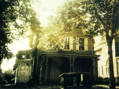
1926 photograph shows the car purchased for Burton Blair in 1919.
Blair, assisted in later years by W. Charles Ross, Wilbur E. Duryea, and for a brief
period Ervin L. Gerding, retired in 1944. Like Blair and Trapier, these men were trained
in engineering – some had degrees; others served with the Army Corps of Engineers.
William P. Webb and Jim Burns were the last to be hired for surveying. It became more
practical for the Company to hire outside Surveyors by the mid-twentieth century. The
volume of work, particularly with the introduction of homeowners coverage, was too
demanding to be handled by the office staff and as a result, the Company turned to outside
agencies, which they continue to use today. Each property insured receives the same careful
inspection as that arranged by the Board of Directors on May 16th, 1752, to ensure equitable
premiums today as in the past.
The value of fire insurance surveys extends far beyond their original purpose, however.
Often insurance surveys, done by The Philadelphia Contributionship or some of the
city’s later insurance companies, provide the only description, either written or
visual, of Philadelphia’s homes and institutions, particularly in the eighteenth
and early nineteenth centuries. Fire insurance sur veys are among the most useful and
least utilized records available today for trying to recapture a sense of the city’s
early plan and the location of its inhabitants. Architectural and social historians have
found these records particularly useful, for they describe houses of all economic ranges
– not merely the elaborate or unique buildings. While many enumerate features of
buildings by noted architects such as Robert Smith, Thomas U. Walter, Wilson Eyre, and
I.M. Pei, many more were done by anonymous builders of each period. The survey provides
at worst a fleeting glimpse, and at best a detailed description, of the exterior of each
house as well as the interior finishing.
Architects and homeowners seeking to restore homes throughout the city and suburbs
have used these records frequently. Obviously the more detailed the survey, the easier
it is to restore a building accurately. Because surveys were increasingly more complete
after 1840, homes surveyed in the late nineteenth century have much more extensive
documentation than those done in the eighteenth century. Partially because of the
inadequate documentation of the appearance of Benjamin Franklin’s home during his
residence there, Independence National Historical Park decided to erect only the steel
frame of the building in the 1970s instead of reconstructing the entire house. This much
information was well documented by insur ance surveys.
Other eighteenth century homes such as the Nathaniel Irish house (Figure 17) at
704 S. Front Street fared better, for while the original survey done in 1772 was scant,
later resurveys (1840, 1893, 1904, 1955) yielded much more complete descriptions
of the property, allowing for detailed restoration. Young’s Meats (Figure 18), at
120 Market Street, initially insured for another firm in 1866, had only the one survey
to record its features, but this survey was more than adequate for their restoration.
Today’s survey with its emphasis on precise measurements and construction and
engineering features provides a detailed record for the Contributionship’s insurance
needs. Coincidentally it will provide a record for the future of this era’s
architecture. In the past 35 years, Philadelphia has seen a renaissance in its older
neighborhoods; particularly Society Hill, Olde City, Southwark, Washington Square and
Spring Garden. Much of this restoration has been aided by the use of insurance surveys.
The work of today’s Surveyors, notably their use of photography, should prove as
useful to future generations as their predecessors’ work has been to us. By
establishing the very practical precedent of requiring that all prospective properties
be surveyed, the first Directors of The Philadelphia Contributionship fortuitously began
a chronicle of Philadelphia architecture which will continue throughout the centuries.